Quick Comms: The Map
Also known as the graphic, the web, and the firmament.
Before we jump right into Q stuff, let’s first talk philosophically on the purpose of a map, how they are made, some boy scout logic, and what separates maps from things like flow charts, blueprints, graphics and diagrams.
Okay, what is a map?
Technically, it’s a two-dimensional, top-down representation of the spatial relationships between points of interest, their borders, and typically maintains a scale ratio to the actual landscape. There are icons, or symbols, representing unique vistas that help you orient yourself, lines that define where you can and cannot walk, colors used to denote separate biomes or regions, and a series of tools that allow the user to determine distance with mathematical accuracy.
You’ve probably heard terms like, Legend, Key, Graphic, Data, Compass, etc. in reference to maps.
Well, a Legend is the part of a Map that effectively defines terms by way of iconography, kind of like a visual dictionary. It is also called a Key because it is the component of the map that permits the viewer to interpret the Map. Without the Key it is possible to obfuscate the purpose of the Map. For instance, without icons being clearly defined, a flag symbol like 🚩 has no meaning to someone who has never viewed the Map. If there are dozens of that same symbol it requires a process of deduction to exclude what it can and cannot be until you arrive at a logically sound conclusion as to what it represents. If a 🚩symbol is often found next to highways, never found in known domicile areas, and sometimes several are positioned across from one another on the same street we can feel pretty confident they represent gas stations. Therefore, based on context, you can establish meaning without explicitly using a Key to do so.
If a ╥ symbol keeps popping up next to blue bordered blob shapes but nowhere else you may consider it has something to do with boats, like a dock. It kinda looks like a dock or pier, so that’s an example of an accurate symbol representation. Blue blobs then also can be seen to represent waterways, ditches, reservoirs, ponds, and lakes.
Do you see how this all is starting to sound eerily similar to how my Comms Dictionary also connects idiomatic symbols using context?
That’s the logical method I’ve used to piece it together, anyways. I don’t have the Key, but what we all do have are news stories and popular media that the Cabal uses as vehicles to send their messages. By looking at them frequently, and focusing in on the context, one may be able to devise the purpose of each symbolic, idiomatic expression and assign a value or meaning to them. Context, therefore, becomes the KEY in unlocking the MAP, such that the Key becomes the Map. It’s no different than trying to interpret the meanings of a map when the Key or Legend are absent. You need to use deduction, logic, analysis, pattern recognition, and a degree of vicarious “how would I make a map” troubleshooting in order to come to workable conclusions.
Now, before I get in too deep, let’s cover some groundwork first.
How It’s Made
How are maps made?
Well, first we should probably ask WHY maps are made, right?
Maps are made primarily so that you can accurately detail your surroundings to someone who may not know the area like you do. At the very least it helps them remember their instructions. If I tell you to go to the store and pick up some bread, unless you’ve made that journey before you’ll have no idea how to get there. Furthermore, even if you manage to wander there you’ll have no hope of remembering every step you took in your meandering because you were too busy just trying to find the place.
That’s no good.
So, I draw what I have in my mind down so you have some reference by which you can navigate otherwise “uncharted waters.”
By following the map, you no longer have to take an indistinct amount of time to complete the task. Instead of a puzzle, like a knot that needs to be untied, I’ve given you the solution and your only hurdle is in how closely you follow the instructions. My task is to make sure the instructions are as sensible as possible. Adhering to your more innate instincts like depicting the store on the map with a big box like [STORE] definitely gets the meaning across, so I include that. Arrows, as well, are innately understood by nearly every human starting in infancy, so I throw some of those in too. I even draw in two colors, with the path to follow in a stark red while everything else is in black.
Despite my best efforts, however, I have no means by which to successfully plot out the area with any degree of mathematical accuracy. Because it would take too long for me to count steps between here and the store as well as their exact angle from each turning point, it is far easier to put visually stark landmarks on the map that I know will grab your attention. Large objects work best for this because they stand out upon the horizon. Bright colors and signage also can assist in an urban environment. Basically, if I can draw it on the map and have it be recognizable it’s a serviceable landmark because there’s less room for subjective interpretation to creep in and confuse you.
Whether they be scenic vistas, landmarks, signs, or otherwise, we can group them all together using the same term “Marker.” While you follow the path on the map you may pass a marker, registering in your mind some percentage of progress towards the ultimate destination. If I set aside three markers, and you’ve cleared two of them, it’s safe to say you’re at least 66% of the way there. If you get lost and miss a marker or two, it’s also possible to use them to reorient yourself. Look for the tallest marker in the distance and head towards it to get back on the right path.
In Comms, this is exactly like watching a movie or some other media form to re-establish or reinforce the correct path and context for the marker. Since everything in the news is dated, for instance, you can look back on the “Map” which is revealed by the News and see which big stories have come and went. If you have some idea of the full Map, you need only see where the marker must lie on the map and wait for the next marker to come up. It’s not all that foreign of a concept, either. You use this logical tool more frequently than you possibly realize.
Say you’re waiting for your food in a restaurant. What temporal markers might you use to discern when your food will be ready? The most obvious is your waitress coming towards your table with a platter in hand. The simple passage of time is also a potential marker, sure, but there’s one that a lot of people fail to track.
Look at the door.
Keep track of the people coming and going.
Every time another party leaves you are one step closer to your turn to leave. While not completely reliable, it is a good measure for whether or not your food is about ready. You can estimate the number of seating positions to determine the maximum capacity for the restaurant, count the number of parties that have come and gone since you’ve been seated, and when the number of parties who have left are half that of the maximum capacity estimate, it’s safe to assume you’re soon to be served. Otherwise, you will have sat for a longer duration than it takes to eat the food. If it takes an establishment longer to cook the food than it takes for a party to eat the food they will have a line form. If there is no line, then that means you shouldn’t have to wait much longer.
Yet another marker to determine where you are.
If that fails, you just resort to the technique you’ve probably always resort to anyways. Look at the party who was sat before you and see if they have their food yet. If they do, you’re probably up next. There are other factors in that equation, but for the most part it is easier and more practical than my previous, logic-ridden method.
My point is, there are ways to create and recognize markers along a set trajectory, for those willing to think about it. Set, because you know that since you’ve been seated and ordered there are strict events coming down the pipeline. The next markers are you get your food, you eat the food, you may ask for refills, you finish your food, you pay, then you leave. It cannot really happen out of that order.
So too on a well-crafted map do we see markers that are hard to miss. If you find you missed a marker it’ll only be because you weren’t paying attention. They’re there whether or not you’re aware of them. So long as you keep moving along the path, the markers are really only there for those who often get lost and need to reorient themselves.
Boy Scout Logic
Back to maps, however, there’s a principle called “triangulation” that is employed by boy scouts to reorient themselves as well as to simply craft a map from scratch for future reference. Let’s say you have paper and some pens. How do you make a map that is accurate and seriously reflects the area around you such that anyone looking for you can find the map and know where you’ve been?
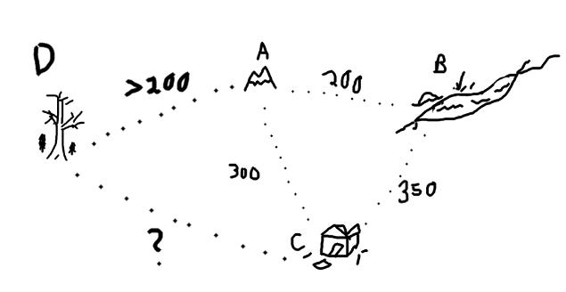
Well, you find a vista that stands out, preferably one you can climb, mark it on the map and then look out to find another marker. Once you’ve spotted another vista, you go there and count your steps. Once you arrive, you mark it on the map and write how many steps it took to reach it. Again, you look out and spot another vista but this time you make sure you can see it and the first vista in the same view. You head out, counting your steps, and then head off towards it. When you get there, you mark it and record the steps, like before, and then set off to your original starting vista marker, again counting the steps. Once you arrive, you will have formed on your map a triangle whose sides are a known number of steps.
Why would you do this, you may ask…
Well, you’ve just started the first triangle component of a web of connected vista points with a quantifiable scale ratio. By looking off into the distance from any one of those vistas, you can calculate with reasonable accuracy the distance any new, far-off vista is from your current position. If you know going from marker A to marker B takes half a day, and vista D which you have not been to is further from A than B is to A, then looking at them from C you can figure that the journey will take more than half a day at least. You may then consider if you have enough energy or resources to make the trek.
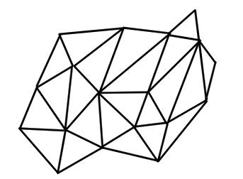
As you add more markers to the map, you build upon it and form a loose but accurate graphic of your surroundings. At the very least, other people will have some lay of the land should they need to reference your map. For the most part, however, you begin to create a web of markers which all form a cohesive whole. The more you add, including the steps, the more you flesh out the web until you have a diagram simplified like so:
With all those markers forming intersection nodes, you’ve effectively created a mesh which accurately represents the scope and scale of your surroundings. Using the Pythagorean theorem, a2 + b2 = c2 you can calculate distances to nodes you haven’t even been to yet. So long as you have two sides established, the rest can fill itself in.
This is how settlers in the American Frontiers kept track of their surroundings.
As well as sailors at sea keeping track of landmasses and cross-referencing them with the known position of the stars.
All this logic also holds true with Comms.
If water = information and sheep = normie, then what is wool?
Well, wool insulates you from the rain and cold. If water is information, then rain(new information) drops out of the air(rumor/gossip). If sheep are normies, then wool(insulation/cover) is a combination of threads(stories) that protect you from the news falling on you.
Cover stories.
In other words, if a storm(declass) is brewing you can trim normies to create some stories to protect you. You can create a gang of fanatics who will support you even when bad news about you comes out because you’ve gained their trust.
If things get violent, they’re basically your meat sheild.
Throw in a few “scapegoats” and you’ve got a heck of a political defense.
How I pieced together these Comms is identical to how I connected the literal maps above to reveal a web.
Cabal spiders(programmer/recruiters) work together to build a network(web) to trap flies(feeders). If flies are listeners, like flies on the wall, then what is basically being said by Q is that the Cabal created a loose organization of agents that work together to collect the rumors/gossip(air/flying) that goes on around the world to formulate a plan. They trap flies, suck out the juices, and use the meaty information to plan around White Hat movements.
Basically a modern form of scrying. Think: Project Lookingglass.
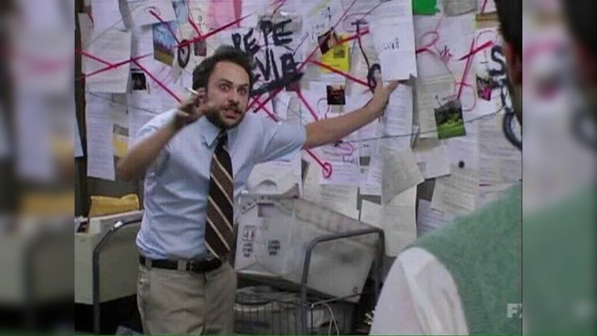
This map-building process is identical to connecting tons of people together like in this conspiracist meme:
This is why they have stigmatized the process so rigorously to cast anyone putting together these connections as crazy conspiracy theorists. Everyone, deep down, knows that corruption is embedded in every facet of government, but they’re too afraid to dig in and show how the spiders built their webs because they don’t wanna look like the above stereotype.
The fear of being labeled an outsider is a very powerful tool.
Peer Pressure.
Just like how people gawk and roll their eyes when a boy scout comes along and tries to show people all these navigational tools. People don’t care because they figure they’ll never need to learn to build a map in the wild. What most don’t understand is that the same process is applicable not only in building literal maps, it’s also useful in building Comms maps.
That’s why I’m working hard to express these ideas to you on a fundamental level, because it allows you to turn them into a Key to unlock the Map. By acquiring these skills, hopefully you may now open a door into a world for which you once had no terms to describe.
You gotta start thinking practically, with real world experience using analogous techniques. Once you expand your horizons, thinking freely, you begin to see that everything is connected both literally AND figuratively.
Symbols are everywhere, and they aren’t just thrown around for no reason. The Cabal uses them. Frequently.
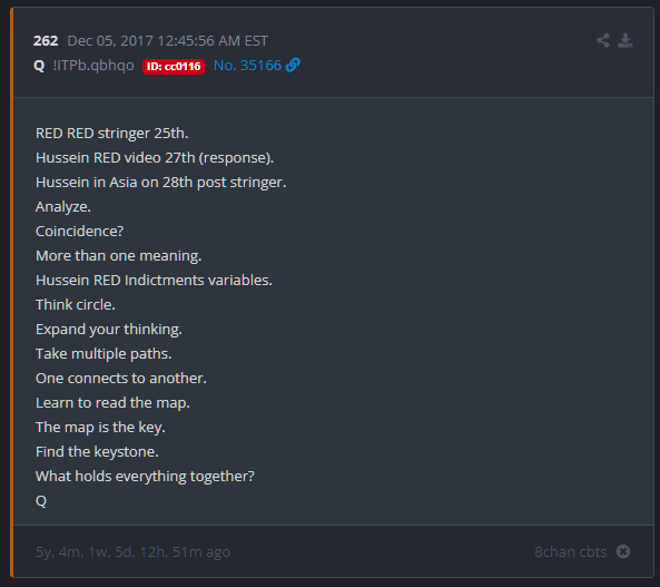
You just gotta find the Key yourself by reverse-engineering the Map using the News as a hotbed of examples and samples. The Key is the Map, but it requires a decode. Many Q posts show us these terms and gives us some starting points, just like building a triangulation map in the boy scouts.
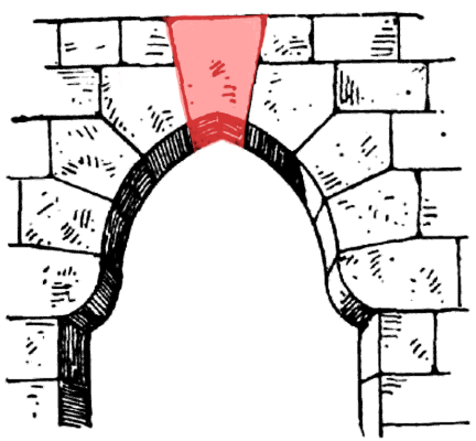
The Keystone is the marker at the center of them all, in a figurative sense, which has the most connections through all other bricks. On a map, the Keystone is like the first three vistas which formed the core triangulation. Everything else scales from those original three sides.
A Triangle.
In architecture, the Keystone is the brick in the top of an arch that keeps everything together. It’s simultaneously the most fortified and most vulnerable of all the stones in the arch.
Remove the Keystone and everything else comes crumbling down.
But, how do you remove the Keystone without everything crumbling?
How do you remove the corruption without dooming the nation?
Build the map. Find the answer.




Always great stuff my fren ❤️🧀